JAXA and NTT DATA Launch Joint Research on Space-borne Laser Altimeter to Create Advanced 3D Map
March 26, 2021
National Research & Development Agency
Japan Aerospace Exploration Agency
NTT DATA Corporation
March 26, 2021, Tokyo — Japan Aerospace Exploration Agency (JAXA), the Japanese national aerospace and space agency, and NTT DATA Corporation, a leading digital business and IT services provider, will jointly conduct research to enhance the precision of three-dimensional mapping using laser altimeters (LIDAR1) mounted on a satellite or other spacecraft.
The purpose of this joint research is to solve the technical challenges in 3D mapping from satellites over forest areas covered with trees and vegetation, and to improve the accuracy of 3D maps used in a variety of fields such as disaster response and management as well as preparing various types of hazard maps in the world. The research period will be from January 2021 to March 2022.
JAXA has been conducting research and development on earth observation using laser altimeters. In this joint research, JAXA will study the technology to measure the height of the ground surface more accurately using space-borne laser altimeter data to contribute to the improvement of the 3D mapping.
NTT DATA has been providing digital 3D maps named AW3D2, which are the world’s most precise pre-produced global digital elevation models and have been used in over 2,000 projects in more than 130 countries. In this joint research, NTT DATA will study the technology to create a more accurate digital terrain model by combining satellite-derived digital elevation models with the elevation of the ground surface measured by the space-borne laser altimeter.
Toshiyoshi Kimura, director of sensor system research group at JAXA, stated: “We plan to utilize the results from this project for further research and development on space-borne laser altimeters, and contribute to greater precision in 3D mapping.”
Daiki Nozaki, head of the social innovation division at NTT DATA, said: “We are confident that we can make the best use of our 3D technology developed in creating AW3D and can contribute to developing advanced hazard maps which have so far been limited in emerging countries.”
Going forward, JAXA and NTT DATA will utilize the results from this study to pursue further research on new satellite sensors and data analysis technologies. The two organizations also plan to explore other applications such as for digital twins (a virtual models of cities), and in the environmental assessment of forest resources.
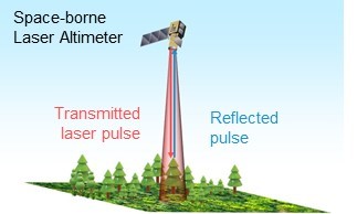
Figure 1:Image of space-borne laser altimeter (C)JAXA
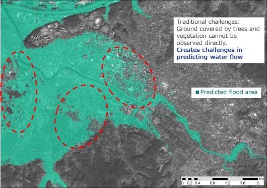
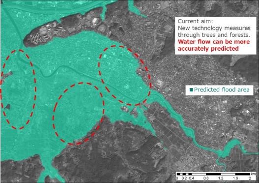
Figure 2:Expected joint research result of advanced hazard map
Left: Estimated flood risk area based on digital surface model (before improvement)
Right:Estimated flood risk area based on digital terrain model (after improvement)
(C)NTT DATA
- (Note 1)LIDAR (Laser Imaging, Detection, and Ranging) is a sensor system that can measure the distance by measuring laser pulse travel time. Space-borne LIDAR can observe ground surface covered by forest and vegetation accurately with wide area coverage, which is difficult to be observed directly by ordinary satellite images. JAXA has experience using laser altimeters on the Hayabusa spacecraft etc., but it is required about 1,000 times higher power in order to use for earth observation purposes due to their high orbital altitudes and atmospheric attenuation. JAXA is now conducting research and development to realize laser altimeters for earth observation.
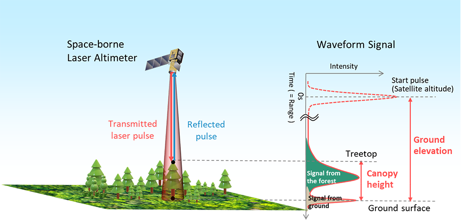
Principle of space-borne laser altimeter (C)JAXA
- (Note 2)AW3D is a high-resolution 3D mapping service with the capability to create images of the earth’s surface at a world-leading resolution of 2.5 meters. The technology has been used for more than 2,000 projects in 130 countries around the world, supporting social and economic advancement through infrastructure development and disaster prevention measures. Website: https://www.aw3d.jp/en/
- *All names of products, companies, and organizations are trademarks or registered trademarks of those companies.
Related Links
Contacts
NTT DATA Corporation
Social Infrastructure Solution Sector
Social Innovation Division
Contact persons: Ken Tsutsui, Mayumi Ichikawa
+81-50-5546-8885
aw3d@kits.nttdata.co.jp
News Releases.
The services, prices of products and services, specifications, telephone numbers, etc. for inquiries and other information included in news releases are the data available on the day of the release. This information may be changed at any time without notice. In certain circumstances, due to various risks or unexpected occurrences, actual results may also be different from the plans or projections in news releases.