DigitalGlobe and NTT DATA Corporation Announce Partnership to Expand Usage of Elevation Data
Feb. 14, 2017
NTT DATA Corporation
Westminster, Colorado, U.S. and Tokyo, Japan, February 14, 2017 - DigitalGlobe, Inc. (NYSE: DGI), the global leader in earth imagery and information about our changing planet, and NTT DATA Corporation (TOKYO: 9613), a leading global IT services provider, have today announced the start of an expanded partnership involving the use of elevation data in their respective products, effective immediately.
DigitalGlobe will offer NTT DATA’s 5-meter digital elevation model (DEM), called AW3DTM Standard, to customers both directly and through its global resellers, bolstering DigitalGlobe’s position as an industry-leading source for imagery and elevation information. For NTT DATA, the arrangement broadens the company’s global sales network and strengthens its role as a DigitalGlobe Information Partner.
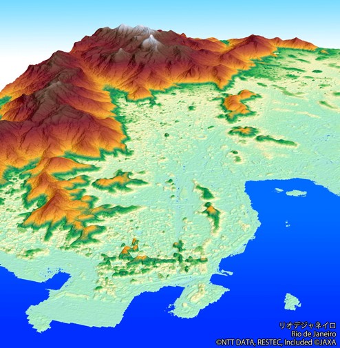
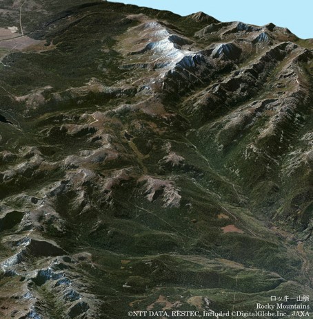
AW3DTM Standard, the industry’s highest-resolution, pre-produced global DEM, is now part of DigitalGlobe’s Elevations Suite of products for wide-ranging applications, such as line-of-sight modelling, urban planning, and floodplain analysis. Applicable industries include telecommunications, civil engineering, and insurance and risk.
“This agreement gives DigitalGlobe customers access to the highest quality and widest variety of readily-available global terrain models,” said James Rogers, DigitalGlobe’s Vice President of Product Marketing and Management. “Paired with our high-accuracy, high-resolution imagery, our customers now have the best data at hand with which to make critical decisions with confidence.”
“Paired with our high-accuracy, high-resolution imagery, our customers now have the best data at hand with which to make critical decisions with confidence.”
“Our partnership enables us to deliver our highest-resolution global dataset to new clients through DigitalGlobe’s global network.”
“Our partnership enables us to deliver our highest-resolution global dataset to new clients through DigitalGlobe’s global network,” said Koji Kato, NTT DATA’s Head of e-Community Division. “New clients in a wide range of fields will now use our data to gain greater insight into a variety of global issues related to the earth’s topography. Going forward, we hope to expand our strategic partnership even further to offer additional value-added products to global clients.”
About DigitalGlobe
DigitalGlobe is a leading provider of commercial high-resolution earth observation and advanced geospatial solutions that help decision makers better understand our changing planet in order to save lives, resources and time. Sourced from the world’s leading constellation, our imagery solutions deliver unmatched coverage and capacity to meet our customers’ most demanding mission requirements. Each day customers in defense and intelligence, public safety, civil agencies, map making and analysis, environmental monitoring, oil and gas exploration, infrastructure management, navigation technology, and providers of location-based services depend on DigitalGlobe data, information, technology and expertise to gain actionable insight.
About NTT DATA Corporation
NTT DATA is a leading IT services provider and global innovation partner headquartered in Tokyo, with business operations in over 50 countries. Our emphasis is on long-term commitment, combining global reach with local intimacy to provide premier professional services varying from consulting and systems development to outsourcing. For more information, visit www.nttdata.com
About AW3DTM
AW3DTM is the world’s most precise pre-produced global 3D map covering all global land spaces with 5 meter resolution, developed and sold jointly with the Remote Sensing Technology Center of Japan (“RESTEC”). AW3DTM has been used in 300 projects, over 70 countries across the globe mainly in emerging countries in Asia and Africa, to contribute to measures for infrastructure, disaster prevention and much more. For more information, visit http://www.aw3d.jp/en/(External Link).
)
)
Notes
“AW3D” is a registered trademark of NTTDATA and RESTEC in Japan, and a registered trademark of NTTDATA in Europe (CTM), and a trademark of NTTDATA in the United States.
For more information, please contact:
Media inquiries:
Public Relations Department
NTT DATA Corporation
Tel: +81-3-5546-8051
About the product:
Otake(Mr.), Shiraishi(Mr.) or Ervianto(Mr.)
3rd Sales and Marketing Group
e-Community Division
Public Sector 1
NTT DATA Corporation
Tel: +81-50-5546-2507